I’m taking a short break off the trail today and I’m enjoying the day in Manchester Center, Vermont with my wife Mary, son Bill, and a great friend from those college and Yellowstone years, Yvette Westbrook, from Eufaula, Alabama. The plan was to do some hiking today, but since I’ve hiked the past three days in the rain and we still don’t have any sunshine today the motivation to hit the trail was at an all time low for this hiker. Tomorrow looks like the weather may improve, so the plan is to get up early and do about twenty miles with Bill while the girls drive to the north end and hike in til they meet up with us and then hike back to the car. Hopefully, they can get a taste of hiking in on the AT in a really beautiful area of New England.
Since leaving Kent, CT, the trail seems to be returning to more remote country, meaning less towns, roads, and background urban noises, which I’m liking. I’m less than a week away now from entering the White Mountains and can’t wait to hit them. It should be one of the bigger highlights of my journey as I head to Maine shortly after. I hear that little to no cell phone service exists in the Whites as well as much of the wilderness areas of Maine so it may be a while before getting another update posted on my blog.
The trail was beautiful as I left Connecticut and entered into Massachusetts along a ravine in the mountains.
While in Massachusetts I stayed at the Upper Goose Pond Cabin which turned out to be a great place and the caretaker sent us off the next morning full of pancakes and fresh coffee. I’m seeing more and more beaver ponds as I move north on the trail. I’m very impressed by the construction talent of a beaver.
The trail passes by Bascom Lodge on Mt. Greylock which is the highest point in Massachusetts.
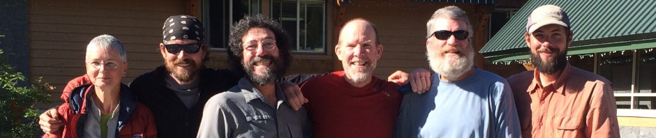
The photos below were taken around the Mt. Stratton area including me standing in the top of the fire tower on the summit.
Time to get off this computer and get my feet moving on towards the White Mountains of New Hampshire.
I’m moving on the slower side these days since leaving New York. At least I thought I was out of New York. I’ve been having too much fun the past several days with a good friend of mine from Connecticut, Michael Morgan. He is a fishing buddy and neighbor of mine in Orange Beach, Alabama. He is a great guy and graduated from Auburn as well! The trail leaving Fort Montgomery has been great although I had a 24 hour period there with lots of rain. I did enjoy lots of deli stops and even a mobile road side pizza place right at an A.T. trail crossing. Life’s been good in the food consumption category these days. However, I weigh less now than when I graduated from college!
The forest through Connecticut so far has been beautiful. I even hiked along a river that would be fun to take my kayak down. Man, I’m going to be ready for some river fun when I get back to the Southeast.
So I’m in the town of Kent, Connecticut and my friend tells me he’s coming to get me for some R&R (that means lots of beer is involved). When he also mentioned a trip into New York City, I could not turn it down. We went today and I truly enjoyed my first visit into the Big Apple.
Going and visiting the new 9/11 Memorial at Ground Zero gave me a unique feeling knowing what happened on the very ground on which I was standing.
Here are some additional photos from my New York City side trip.
Tomorrow I need to get back on the trail and make some miles up quick. It’s been FUN, but time to continue north to Maine!
Today marks three months now that I’ve been on the trail and what a journey it’s been so far. The miles seem to be adding up much faster these days as I have less than two months before ending my adventure in Maine. It’s pretty neat to be counting down the miles remaining now in three digits. It’s still a long way to go and a lot more ground to cover, but each week seems to be passing by faster and faster.
I hiked out of Pennsylvania with an old Yellowstone roommate of mine from 1980, Doug Berg. It was great fun catching up with Doug out on the trail. I hope I have him talked into coming down south sometime for a visit. He told me he has always wanted to see Alabama since his dad was born there.
The last two days in Pennsylvania we saw two different fawns on the trail, the one above and this rare white fawn below.
Here are a couple of additional photos from my last days on the trail in PA.
From Delaware Water Gap, PA I crossed over the Delaware River and into New Jersey and visited the 220′ tower marking the highest point in the state.
From New Jersey I went into New York and was greeted by my first rattlesnake of the trip. I’m really enjoying the hiking here in New York. It’s lots of work, but fun! I’ve been within 34 miles of New York City now and have seen the skyline several times from different mountain tops. We also were treated with some great trail magic in New York…hot dogs and sweet tea.
Wow..Since my last blog update I’ve covered a lot of ground and passed a number of classic spots and milestones along the trail. So with my limited time on a computer here at the library in Hamburg, I’m just going to get started with my brief descriptions and pictures below. Enjoy!
The first spot was the Bears Den Hostel. Didn’t stay there but enjoyed a nice break and a Mountain Dew. It’s really a great looking hostel.
After leaving the Bears Den, we found the Horseshoe Curve Restaurant just off the trail a bit and enjoyed a late afternoon lunch. We left after 4:00 p.m. and still had 11 more miles to hike that day.
My friend and high school classmate from 1978, Rob Mayville, met me in Front Royal, VA and basically hiked with me for a week. It was great fun and I really enjoyed meeting and getting to know his wife Melissa. Many thanks to both of them for all the shuttles, meals, and spirits.
The first big milestone was going over the 1,000 mile mark at the Virginia – West Virgina border.
Next was hiking through Harpers Ferry, WV and checking in at the Appalachian Trail Conservancy. I’m the 149th thru hiker for the year to check in basically at the halfway point to Maine this year. No matter if you started from Amicalola Falls or on top of Springer Mountain, most hikers check in here and have their photo made at the ATC for the record.
a.k.a’s (The Dude, Philly Ben, Whitewater, Uno, and Sketch at the ATC)
The trail goes through many historical sites along the way including the first Washington Monument.
Another big milestone was passing the halfway point on the AT…just HUGE!!
I set a new personal best, doing a 29.4 mile day into Duncannon, PA with the Warrior Hikers. Mark and Sean, Warrior Hike, were special guests in the Duncannon Memorial Day town parade the next morning. It was fun to stay around town long enough to watch them come down the street in their special ride.
A few of us stayed at Mary’s home which was located just above the local PUB in town. Mary is a very popular and well-known trail angel who helps and support thru hikers coming through the town of Duncannon. She also left us sodas and burritos along the trail as we were coming into town.
A few random photos from the past couple of weeks…
I’m in Front Royal, VA at the moment, but looking forward to leaving the state of Virginia behind and moving on to Harpers Ferry, WV by the weekend and the halfway point on the trail. I enjoyed Virginia, but I’m ready to move on. Virginia holds more A.T. miles than any other state at roughly 520 miles, so let’s just say you’re here for a while.
I guess I learned where all the wildlife on the A.T. can be found…in Shenandoah National Park. Even though most hikers get tired of hiking close to Skyline Drive and hearing the traffic of cars go by, seeing seven bears and a large number of deer was very cool! The trail through the park was fairly easy compared to what I’ve been experiencing which was a nice relief as well. I did have several days of rain in a row which makes pulling out the camera difficult, but I still managed to get a few good photos off.
It was really hard to get photos of the bears. By the time you get your camera out and turned on, most of the bears, once they see you, head back into the woods fairly quickly, especially the ones with small cubs. I’m not taking a zero here, so I’ve got to run and hit some miles on the trail this afternoon. Enjoy a few photos from the past week or so.
Had a short day on Friday after crossing the footbridge at the James River west of Glasgow, Mary drove up from Lawrenceville and picked me up at the local ball park in town. I’m in Lexington, VA at the moment spending the day with Ms. Mary, eating very well and doing some badly needed resupply and gear change out for my next stop in five days in Waynesboro, VA.
The weather went from snow to 91 degree temperatures on the trail in about a one week time period and I have to say I’ve really been hiking in air conditioning since I left in March. This heat is going to take some getting used to. Thank goodness, I think the leaves are finally coming out even at the higher elevations and giving some relief from the intense sun and heat. Even though the water is cold right now, I’m already taking advantage of any swimming holes I cross along the way.
Out of Pearisberg one of the first stops I made along the trail was at the Audie Murphy Monument. Murphy was the most decorated American soldier of World War II who died in an airplane crash near the A.T. in 1971.
From the Audie Murphy Monument, I went on down the trail to see mother nature’s version of what I call in the construction business a tilt wall panel, the Dragons Tooth (stone monolith).
The trail both up and down from the Dragons Tooth was a challenge to say the least with a thirty plus pound pack on my back. Being careful not to make a stupid mistake that would take me off the trail was always first in my mind, but I had to follow some tough white blazes. It turned out to be fun, but was very tiring in the heat.
After coming down from the Dragons Tooth, I hitched a ride down to Catawba, VA on an early Sunday afternoon for lunch at The Homeplace Restaurant. Needless to say after spending three days on the trail I felt a little under dressed, but I sure enjoyed the clean smell of those there in their Sunday best. All I can say is if you ever have a chance to eat here, go for it. You won’t be disappointed! The meal was $13.00 for all you could eat and drink. Most hikers seem to find this spot and it’s truly amazing the amount of food that can be consumed by one person! It took me a couple of hours to recover lying down in the yard beside one of the gazebos in the shade. After a while, I made a full recovery. By the way, that’s not me lying in the grass below, but another fellow hiker who may have over indulged himself!
Being that my stomach was full after eating at The Homeplace Restaurant, I decided to catch the shuttle back to the Four Pines Hostel and stayed there for the night. I was actually six-miles north of the hostel but Joe, the owner, told me that he would give me a ride back to my trail head location on his way into work on Monday if I was willing to leave the house by 6:00 a.m. I was packed and ready when he came through and was looking forward to my short hike up to McAfee Knob and Tinker Cliffs. Unfortunately the weather did not cooperate for me to get the views and photos I was hoping for. Oh well..I’ve been really blessed with great views throughout my journey so far, so I’m not going to be sad about having to come back and revisit McAfee Knob and The Homeplace Restaurant later down the road.
In Daleville, VA I managed to spend way too much time at the local outfitters store there, Outdoors Trails, where the staff and the fine folks on the phone with Osprey Packs put me into a brand new super lightweight exos 58 backpack, saving me two pounds in weight. I would also like to thank Merrell for keeping me in boots on my journey north to Maine.
As most of you know, I’m hiking to help raise money for the Hudson Family Foundation and I hope to have several more fund-raising events late this summer and early fall upon my return. I also want to tell you about another worthy hike to raise awareness and money for our wounded veterans. I’ve had the great pleasure to spend some time with both Mark and Sean and I can tell you these guys are genuine young men. I personally want to thank them both for their multiple tours in both Iraq and Afghanistan. Please take a moment to visit and make a contribution to the Warrior Hike.
One day while eating lunch at a shelter we noticed a Black Snake in the rafters. By the time we finished our lunch, we finally figured out what he was up to. He needed some lunch too! Check out this video below.
I’m alive and still doing great making miles north to Maine. Since leaving Damascus I’ve enjoyed many new spots and sites along the trail. Out of Damascus I hiked along and on the Virginia Creeper Trail. The Virginia Creeper Trail stretches 34 miles from Abingdon, Virginia down through the town of Damascus along the Whitetop Laurel River and up to its highest point, Whitetop Station, near the NC State Line at Whitetop, Virginia. The Virginia Creeper Trail is open to hiking, mountain biking and horseback riding.
The trail is a former rail bed that passes through the Mount Rogers National Recreation area and the highland country of Southwestern Virginia. The Virginia Creeper Trail is rich in beauty and regional history. I’m looking forward to returning to Damascus next year and taking the biking trail through the mountains.
From the Virginia Creeper, I hiked on to Buzzard Rock, which is a bald near the top of Whitetop Mountain with great panoramic views, and on to Mount Rogers, Virginia’s highest peak at 5,729 ft. I also visited the Settlers Museum along the A.T. which is the only museum in the country on National Forest Service property. All the buildings are in their original location. The old schoolhouse was just awesome.
After Mount Rogers, I hiked through the Grayson Highlands State Park where I was greeted with number of wild ponies. It was very cool and made for a fun day of hiking. In the Grayson Highlands, the A.T. goes through a spot called the Fatman Squeeze (a rock tunnel). The next day the weather turned cold, wet and windy with some sleet mixed in. Not a good combination for hiking, so after reaching the Mt. Rogers Visitor Center, I decided to head into Marion, VA for the afternoon and evening. The next morning we all learned about a fellow hiker, a.k.a “Dago”, who was found in severe hypothermia by a nurse who was day hiking. Not good!
After leaving Bland, VA, the weather turned to wet, cold and snow which made for some interesting hiking for a couple of days, but I took another break from the weather and stayed at the Woods Hole Hostel. What a neat place for a hiker to spend the evening, get some great meals, and be treated like family!
Made it to Damascus, Virgina on Friday the 13th with plenty of time to enjoy a meat lovers pizza and some pure Rocky Mountain Spring Water. Had a great week of hiking from Erwin to here with four days of doing twenty plus miles per day. My biggest mileage day so far was Friday coming into town doing 27 miles. So being that I’m now a couple of days ahead of my very flexible schedule, I’m taking a zero day today. I’m able to take advantage of the library here in Damascus to update my blog and connect my camera as well to upload lots of new photos.
The weather was great this week, but very cold. I gave up my winter clothes and sleeping bag in Erwin and of course from there I’ve had some of the coldest weather on the trip so far. One night the temperature dropped to 23 degrees! Let’s just say it was a long night of trying to stay warm with summer weight gear, but I survived.
Had a wonderful stay at the Mountain Harbour Hostel in Roan, TN sleeping above the goats in the barn, but the hikers were welcome to join the other guests staying in the bed and breakfast inn for the morning meal and coffee.
One of the photos below is the Overmountain Shelter which is an old barn that has been converted to an A.T. shelter. The night I stayed there we probably had thirty thru-hikers staying in the barn. It’s a very popular place to stay for its scenic views and sunrises.
Sorry for the long delay in updating this blog, but I’m in Erwin, TN now and all is going great! Here’s what I’ve been up to since leaving NOC. Since my wife, Mary, is here in Erwin with me on my zero day, I’m able to use my computer and upload many more photos from my real camera onto my blog. So be prepared to enjoy some additional photos here and there.
I went from NOC to Fontana which is the south entrance of Great Smoky Mountains National Park. I hiked across Fontana Dam and on into the Smokies. I came out four days later with a whole new appreciation for these mountains. After spending almost all my life looking up at these mountains, I never thought they compared to the Rockies of the west. Boy have I’ve been wrong! After hiking across the tops of these mountains and looking at the incredible rock faces seen from the ridges, I can certainly say that they are just as beautiful and rugged as those of the west. The trail through the Smokies took me up and over the highest point on the Appalachian Trail, Clingmans Dome, at an elevation of 6,643 feet. All I’m sure about is the rest of the Appalachian Trail won’t be all down hill from there.
The Shelters throughout Smokies were really nice and the best I’ve seen on the trail so far. They able to handle plenty of thru-hikers with a double rows of bunks and clear skylights in the roofs.
We made a quick trip down to Gatlinburg one afternoon for overnight stay, meal, and shower only having to make up 3.4 miles the next day to get back on track. That was a No Brainer!!
I took the side trail out to the summit of Mt. Cammerer lookout tower, doing my first twenty-mile day. You can hike all the side trails you want, but they don’t count in the everyday miles to Maine.
After leaving the Smoky Mountains, I arrived at the Standing Bear Hostel which was a pretty cool and very rustic place to stay for the night. It was the first time in my life that I used a washboard to clean my clothes.
From Standing Bear, I had a two day hike to Hot Springs. While in Hot Springs I stayed at Elmers Sunnybank Inn. Just a classic place…it’s an old Victorian home built in the 1840s. Elmer basically caters to thru hikers.
I left Hot Springs for a five day hike into Erwin, TN and able to take shelter before a number of bad afternoon thunder storms. I was also thrilled to hit a couple of Trail Magic spots along the way.
Since arriving in Erwin our good friends Green and Callie Faircloth have opened their home here in Erwin to me and a number of fellow thru hikers taking us on resupply stops and feeding us well along the way. Many thanks!!
I made it into NOC yesterday in time for a late lunch at the Rivers End Restaurant. The cheeseburger, fries and beer went down without any problems. Later that afternoon, my Mom and Dad drove up from Marietta and joined me for dinner. I think they enjoyed getting to know some fellow hikers and it is very comforting for them to know that I am not alone on my trek. At dinner we were talking with Waldo(trail name),a young guy who has decided to end his attempt of a thru- hike. He is buying a bike instead and riding it back home to Virginia Beach. By the end of dinner my mom got up and gave Waldo a hug and wished him well. Pretty cool…for my mom.
Since I got to NOC a day early, I’ve decided to go ahead and take a zero today and rest my old bones after the first 12 days on the trail. I feel like I’m beginning to get my trail legs under me now and I’m very pleased that I have managed to do 146 miles in the first 12 days out of Amicalola Falls. I’m trying to stay flexible, but I probably won’t take another day off until I reach Erwin, TN around April 7th.
While killing time here today, I was going to check in with the guys at the outfitter store to see if I could borrow a kayak for a while and play around behind the store. I’m going to really miss my kayaking fun this spring and summer so I thought as well try to get some water time in. It didn’t happen, but I enjoyed playing cards with some other hikers for a while. One of my fellow hikers (on the trail for his 2nd thru hike) gave me my trail name tonight. It is “Whitewater“. I accepted it and think it is a perfect fit for me!
Looking forward to my journey through the Smoky Mountains.