From all of our group on this river trip, many thanks again to the staff and guides at AZRA and Current Adventures for making our trip down the Colorado River through the Grand Canyon a lifetime experience and a very special memory for us all. I’m completely aware that a trip like this is not for everyone, but I do wish that those who choose not to do outdoor adventures could just see through my eyes for a brief moment and experience all the beauty this world offers. We’re truly blessed with a planet full of spectacular scenery!
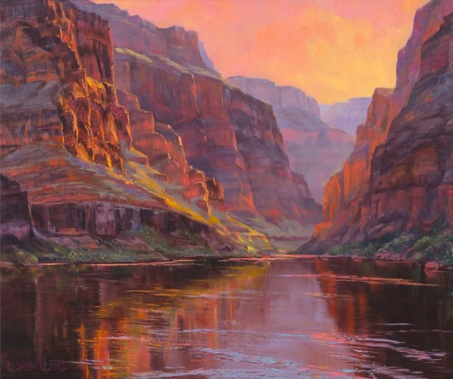
Just a quick note on the painting above by Dawn Sutherland. I love this painting and to me it’s able to capture all the beauty of the canyon far beyond that of a photo. I asked Dawn for permission to use a copy of her painting in my blog and she was fine with that. Dawn ended up sharing with me the full background about the painting as well. Thank you Dawn!
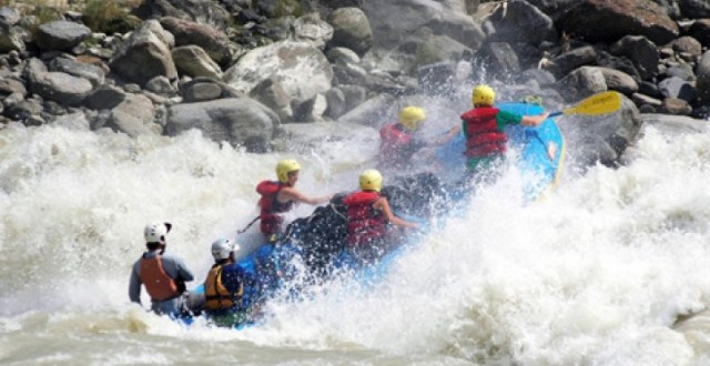
As usual, we didn’t stop on the river banks to take photos running the rapids along the way. However, several of us did have helmet cams through a number of the whitewater sections. It’s sad, but true, I have not taken the time to put together a trip video yet except for this short clip below of running Lava Falls. Hopefully, someday I’ll get a chance to go through all the video clips taken and be able to put the best of the best together in one video. A few old whitewater videos from a 2013 trip down the Colorado River can be found here.
UPDATE 11/4/20: A new Grand Canyon / Colorado River 2019 video is linked here. Enjoy!
The following blog update was prepared and written by Bob Sarratt and was taken from his journal entries that he kept along the way. Thank you for sharing, Bob!
Grand Canyon August 28th to September 10, 2019
![]()
Well, at least I didn’t swim today! Day 2 on the Colorado River has lined up to beat all expectations! BIG WATER, exploding waves, eddies in the middle of the rapids, insane whirlpools at the bottom of the Rapids – it’s all here along with the most amazing scenery on the planet. It’s on this second day that I start writing this journal. Here goes…
Day 1, Wednesday 8-28-19, mile 0 to 16.5
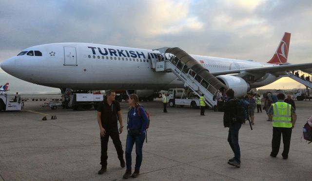
The drive from Flagstaff was amazing! Bill was our AZRA bus driver who looked a lot like Sandra’s cousin Gus Lott. On the way to Lees ferry, we stopped in Cameron Arizona for a bathroom break and to see the Little Colorado River. What we saw was a dry riverbed. We all enjoyed browsing through the Native American gift shop and then piling back onto our bus for the last 45 minutes to Lees ferry. We are all very excited. We did learn in the parking lot in Cameron the value of shade. This lesson would be continued for the next two weeks. While in the parking lot our trip leader, Robby, was asking how much hiking we wanted to do on the trip. We did all of this from the shade of the bus because being in the direct sunlight was a tad bit Hot, to say the least. The group said we want to hike everywhere possible! Our plans were set, and off towards the put in we went. Just before Lees ferry we stopped at Navajo Bridge. This arch steel bridge spans the entire Colorado River. Our first view of the Colorado 500 feet below – it was a clear mountain stream. You could even see the bottom for a good ways from the bank. We were all really excited to see this awesome view and enjoyed walking across the bridge as Bill drove the bus to the far side. Our first adventure on the Colorado was on foot, walking 500 feet above its surface. What a way to start our journey.


We then pulled off the highway and drove to Lees ferry on the access road. At the end of the road we saw two of the largest rafts I had ever seen. One a “J” rig with 4, 3’ diameter pontoons around an aluminum hull with gear boxes on the deck. The other was an “S” rig that looked more like a traditional raft with extra pontoons lashed to each side. Each powered by a 30hp Honda 4 stroke outboard. Beside the rafts on the shore were our personal kayaks and gear ready to go – all laid out in a row, just waiting for us to launch. The guides had been working hard the day before and this morning getting everything squared away. We also met our guides from AZRA and Current Adventures:


Robbie ReChord – Trip leader kayak guide, Jasper – swamper guide, Randy Tucker – motor guide, Chelsea Arndt – motor guide and Chad Tucker (Randy’s son) – swamper guide & head cook. Current Adventures kayak guides, Thomas Baumann and Kimba Sprague.
 Robby did a trip safety talk and then we got started on the Colorado. Crystal clear water. Small waves to start off and then got big to the first rapid, Badger at mile 8. Yes, got flipped about half way down on a big wave, rolled up and went thru the rest of the very busy water. Big big waves and eddy lines, like nothing at home. Then on to Soap Creek, another big drop. After a few more miles of fun water we stopped at Hot Na Na to camp. Mile 16.5 . It was a tight campsite area but we all found a good spot for the evening. Dinner this first night was salmon and couscous – it was delicious after a long day on the river. Slept fairly well that night on top of the sleeping bag but it was HOT until about 2am, but the stars were magnificent! A shooting star was the last thing I saw as I fell asleep that night. Excitement from the night was ring tail cat walking over David while he laid on his paco pad sleeping mat!


Day 2, Thursday 8-29-19, mile 16.5 to 29.5
BIG WATER DAY started with a bang at House Rock rapid at mile 17. It is rated a seven on the Colorado river scale (1-10) and yes I flipped. Big right hand turn rapid with a beautiful glossy front wave and then insanity to the left. I flipped on the second wave that came in hard from the left. I executed a weak brace and over I went. Double roll but I got up. “Keep that head down!” Kimba reminded me as I got back upright! 200 yards of whirlpool eddy lines below. What a rapid! We then got into the roaring 20s – a section of fairly continuous white water. At mile 20.5 we stopped at North Canyon for a hike. Walked up a beautiful canyon on river right of swirling rock formations that look like broken glass in layers – sandstone, silica, glass – it’s all similar according to Jasper …awesome unique place. we walked further up in the dry creek bed of this most interesting fractured rock cracked and broken in a circular formation in multiple layers. We arrived at a deep stagnant pool covered in green algae – end of the road, except the guide Thomas Baumann waded thru it and continued up the canyon. Not willing to follow Thomas through the green slime, we soaked up the feeling of being in this place, snacking and napping on the rock.


Thomas then played his wooden recorder (baroque flute) while we napped. Awesome experience. Upon return to the rafts, we had lunch next to the river of turkey sandwiches and all the fixings. After lunch we jumped back into the river and into the roaring 20s. I started to get into the game of riding the big waves and did better with only a few rolls. Everyone did well most of the way through. At mile 26 near Tiger Wash we had three swimmers, including the organizer of this trip! David was spun around on top of a wave – looked like a helicopter and then upside down and into a weird eddy. I was tending to Bill who had already swam – while working with him to get him to shore, he got sucked down into a whirlpool. He was under several seconds and came up like a submarine on emergency ballast surface! He was fine and after a big laugh and towing David’s boat back to him (who was now safe in the raft) we got down to our camp at Silver Grotto. We camped in a dry wash and put up the Eno tarp for some shade. Dinner of chicken rice and bean burritos. After dinner, we read aloud a chapter from Up Shit Creek, Joe Lindsey’s book that we discovered from our trip to the middle fork of the Salmon in Idaho. Joe was one of our guides on that trip and a great author and trumpet player. Boatman Randy really enjoyed the reading! After some big laughs, I then came back to the tent, sat in the ENO chairs next to the tent, watch some stars, then took a bath in the river next to some rocks, and then on to bed. What a great day. And it’s only day 2.


Day3, Friday 8-30-19, mile 29.5 to 47.5
Chill day. Flat water with two named rapids. the ducky boat came out with Jen and Vicky using it first. Small riffles than a big rapid which sucked them down in a whirlpool. Two more swimmers in the club! Further downstream we stopped at Red Wall Caverns. A huge room in the canyon wall on river left – gigantic room for a break. Paced it off at 87 paces by 69 paces . We hung out, some threw the frisbee and napped. That was mile 33.


We then drifted a little ways to lunch at the Marble Canyon dam site. We explored the test holes that were 400 feet deep into the rock. The test holes were impressive with their meticulous marking and the size of them. Impressive engineering and grit. Amazing in its own right, but so thankful the dam plans were scuttled in the 50’s at the persuasion of Martin Litton.


After getting back on the river the ducky was piloted by Joe and Stan. They did great. Our current adventure guides Thomas and Kimba are from California. Thomas was born in Germany and does the best raven call since he is an ornithologist. He also has the nickname of “raven” because he will steal your food if you’re not looking! Kimba is great and takes the easier lines. He is a lot of fun to follow. At President Harding rapid I didn’t follow Kim and flipped on wave number three. I waited three or four waves to roll and then I hit it. Later Kim and Thomas shook my hand for the iron lung award. I had a good big breath on that one. We paddled an S-curve part of the river and ended up at saddle Canyon for camp. That’s where I am now writing this entry to the journal – right by the river. Nancy and Sandra in ENO chairs as we cool off in the water. Solar charging phones and having a beer or two. We had dinner of chicken pasta. We camped up on a knoll away from the river and it was very hot. Slept on the sand mat that night to try to stay cool to no avail. Tomorrow we see the Little Colorado River!


Day 4, Saturday 8-31-19, mile 47.5 to 63.5
Writing this entry with red headlamp overhearing Joe and Stan laugh and talk. What a great sound with the river and crickets as we wind down from another chill day on the river. We got up this morning to breakfast burritos and coffee after a very hot night at Saddle Canyon. Saddle canyon is across from a large red wall that holds a lot of heat. I slept on the sand mat and then in the tent after feeling bugs walking on me. Anyway it was a fun day on small Rapids except one named rapid near mile 58. We stopped at Nankoweap for a hike up to the ancient grainery and a great view of the river – a famous shot of a long, fairly straight stretch of river. Very different from the S curve at saddle canyon just a day ago. The hike up was very steep but the view was worth it. I wore Buddy’s AU NROTC cap this day. The Colorado River was on his bucket list, so I wore his hat today and had him with us on the trip.


We then continued onto the confluence of the little Colorado after a wonderful lunch of taco salad at Nankoweap. We stopped at confluence and hiked up to the Little Colorado to find it was solid red instead of clear blue we had hoped for. The water is very red and carries a lot of silt. The Little Colorado gives the main Colorado most of its muddy water. I got back in the water and paddled below the confluence water and sure enough it turned the entire river muddy. John Bagby (Bod) and I started measuring turbidity by seeing how deep we could sink our paddles before the blade label disappeared in the water. After the confluence we could go no deeper than blade deep on our measurement. We now were on the classic muddy Colorado. We then had a few small rapids while Carl and Michelle took the duckie. We then stopped at Fishcamp as it was called by Chelsea the guide. She stops here with her USGS fish survey trips and likes it, so here we are!
Chelsea‘s stepmother is Kenton Grua’s first wife. Kenton, also known as “the factor”, is the one of the guides in the book the Emerald Mile and was a legend of the guiding community.

Anyway, it was a great campsite and we had steaks, potatoes and broccoli for dinner. It was great and all had fun playing Internet medicine with Dr. Andrew where a person describes their ailment and everyone chimes in on cures. Hilarious!
Tomorrow starts with a hike and then then back into big Rapids with Uncar and others! Can’t wait. Oh yeah, War Eagle – Auburn came from behind to beat Oregon 27-21 tonight. It was also John and Hannah‘s and Paul and Sheryl’s anniversaries .
Paul and Sheryl 10 years
John and Hannah 17 years
Great celebration day in the canyon!


Day 5, Sunday 9-1-19, mile 63.5 to 76
Got up to coffee and Mediterranean scramble with hot sauce selection at our camp near mile 63. You know I loved that. Short paddle this morning to Carbon Canyon where we did an amazing hike. Put on water boots (for the first time) and walked up an awesome dry wash amongst Tapeats sandstone and bright angel shale – some of my favorite rock so far. The bright angel shale is full of lines and colors. Stunning. We walked up a mile or so and Sandra decided to stay there as it was getting more rock climb-y than hike-y. She stayed in some deep shade and Chelsea and I said we would come back. The group was going to do a one way hike up Carbon canyon and down the next canyon while the boatmen took the rafts to meet them. The other guides were going to wait on us “up and backers”, as I wanted to have paddled the entire canyon. So we left Sandra in shade and continued up the wash which went fairly steep up. By the way, my wife is the best. Such a trooper and making the best of what she is presented – always has done that. This really is the trip of a lifetime – so blessed to do it with friends and my BEST friend. The carbon canyon walk was amazing. Swirled rock formations in a grotto. We walked to the top and it was like standing at the top of a funnel of rock. Swirling lines in the shale and sandstone. We then followed Thomas on a ninja move and viola, we were in another wash going up even further, but much wider and taller. Got to the very top where we saw out of that level of the canyon and gazed upon a gentle yet desert valley out and away from the river. The top of the canyon the rock went from horizontal lines to vertical, like it were going skyward at the end. Amazing.


 We took pictures and then it was time for Cheslsea and me to head back down Carbon canyon to Sandra and the boats. So hand in hand we skipped away from the group humming wizard of oz, if I only had brain! We head a great hike/climb down the canyon where Chelsea told me about her time with Kenton Grua and even Julia Dreyfus of Seinfeld who came on one of her trips and was so awesome and genuine and funny. Dreyfus talked about her trip on Fallon and said Jimmy couldn’t handle it, she spoke of the beauty and the wildness and the guides caring and hardwork. All we have experienced ourselves!
We walked to Sandra’s spot and found she was not there. Robby was nearby and he told us she had walked on her own back to the boats. Continuing down we found her waiting for us and quite proud of herself for walking back solo. What a trooper!
Chelsea and Randy at the tillers, and Robby and I in kayaks, we took off down river to the next canyon, only a few hundred yards, but a great little wave train with fun surfing was the treat for us river runners. We picked up the hikers and went down to the next stop at Uncar ruins – one of the largest archeological sites in the US. Everywhere we walked we were a on old pot shards and relics. Chad showed us an ancient piece of basket woven from river reeds. We walked all around the area in the open – very hot and dry.


We soaked our bandanas and drapped them on our heads to stay cool. Drank all the water and then went back to the boats. Unkar rapid just below. Lots of big fun water. Left side was Mr Toad’s wild ride with Thomas, right side was easier. After some other big splashy rapids, we wound up at our camp near Neville Rapid. Big Sandy beach camp at mile 76. While pulling into the beach and moor the raft, Chad was starting to tie the S rig to a bush when he jumped back 3’. A small rattlesnake was wound around the bottom of the bush that he didn’t notice until he was starting to tie it off. He said, I think I’ll find another bush! And so he did.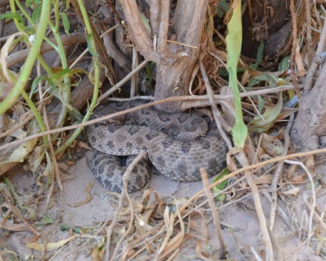 It was a sand beach with great views of the canyon and rapid in front of us. We had a wonderful dinner of grilled ravioli with marinara sauce along with green salad and grilled bread. Yum yum. Very windy though. Sand went everywhere including in the tents and bags. Good drinks help get us through the evening. Vodka and fruit juice! At least we had a breeze even though a hot one. More from Joe Lindsey’s book and off to bed after another amazing day.
Day 6, Monday 9-2-19, mile 76 to 94
BIGGER, BIGGER, BIGGER
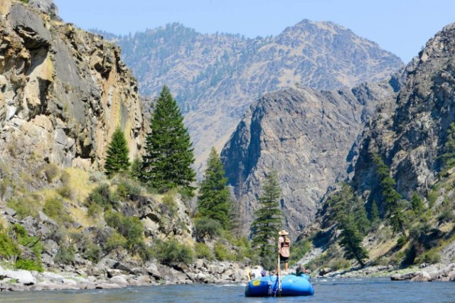
Labor Day breakfast of ham and deviled eggs. What more could I ask for. We packed up and went to scout Hance Rapid. 9 of 10 on the scale. Big stuff for a long bit. We all did great, and then onto Sockdolager (9) and Grapevine (8). The whitewater was just plain big fun. Straightforward lines with gigantic water. Big holes that were avoidable. Thomas set some wilder lines. I followed Kim and Robby with more tame routes. The vertical feeling in those waves was astounding. Then onto Phantom Ranch to look for the pirate stash bourbon I had left back in March while on our hiking trip.

The March Pirate Stash Hole
I found that I’m a bad pirate, the Woodfords Reserve and bearded iris beer I left was gone. The hole evident, but the booty was gone. Someone has the curse of the dread pirate Bob!
We walked to Phantom Ranch commissary, sent post cards, soaked up some air conditioning and drank lemonade with ice. Nice break of civilization. We then headed back to the rafts to see the guides had filled most of our water cans from the water spigot near boater beach. Launched, went under the silver bridge and onto Horn Creek Rapid. From Phantom ranch I felt we were going into even wilder country. Many half trips take out at PR, like Paul had done years before. The next part of the river is what Kevin Fedarko calls God’s Country. Over the next week, we would find just that.


Horn creek rapid was another 8. Bill had a great roll as a rain started. Only big rain of the trip! In three more miles we pulled into Monument Creek Camp in a hard rain. Set up the tarp at our tent camp in amongst the Tamarisk trees and shrubs. A spiny back lizard greeted Stan on one of Joes shirts that was laid out on a rock, and then later chased Stan around inside his tent!
That evening we had Mediterranean lamb, tabouleh, and zucchini. Amazing dinner. Then enjoyed guitar playing from Thomas and Andrew while I tried to join in with harmonica. Bath that night in the clay filled river – cleanest I’ve ever felt. Another great day in the canyon!


Day 7, Tuesday 9-3-19, mile 94 to 109
EPIC rapid day.
Stans birthday, best 6 hrs of boating ever, 2 great hikes in the GC.
We camped last night at Granite Rapid, well actually Monument Creek campsite. We woke up to hot coffee and blueberry pancakes by Randy Tucker.  Randy is awesome, he lives in Green River UT, guides rafts, drives trucks, skis – a real renaissance man. His son Chad is also amazing and works at Brighton Resort in Big Cottonwood Canyon in Salt Lake City.
We hiked up Monument Creek through an interesting chasm – water running thru and then up to a great view of the stone monument, a 100’ tall tower of rock – showing the great non-conformity, a part of the GC that appears in several areas where 800 million year old Tapeats Sandstone sits directly on top of 1.8 billion year old Vishnu Schist. How did a billion year gap happen? We hiked up to one of the parks main trails and saw some hikers and even a back country toilet, but no ordinary toilet according to Randy, it was a Phoenix 3000 solar composting toilet.


We then headed to the river and found the water turned clear overnight and turned out to be the greatest day of whitewater paddling I’ve had to date. Classic drops that I’ve heard of all my life, Granite (9), Hermit (9), Boucher (5) (pronounced Boo shay- like the Waterboy!) Then onto Crystal (10), biggest water yet. We all did great – followed Kim down the right sneak of Crystal – he called it beer right. So close to the right bank, someone can hand you a beer. Thomas ran left to right threading the needle between two huge wave holes and onto the bottom. We then had a boat lunch snack of peanut butter crackers and headed into the rest of the jewel rapids. A way to remember them, TASTRS Tuna 1&2, Aggate, Sapphire, Turquoise, Ruby, Serpentine – which was my favorite. I had to stop and drain my boat and the group went ahead of me, I did the class 8 on my own line solo, amazing experience – huge exploding waves, haystacks and standing waves. BIG,BIG,BIG. We then continued to Bass Rapid and then a short paddle to our camp just upstream of Shinumo Creek. After unloading gear, we all pilled in the rafts and motored about 200 yds down stream to Shinumo Creek and walked up to another waterfall. Swimming, creek floating and naps all around. What a fun AMAZING day! Writing this in camp looking at a great sunset, sipping bourbon with ICE – a treat from AZRA. Getting ready for Chicken Curry dinner. Super day!
Day 8, Wednesday 9-4-19, mile 109 to 126
We left Bass camp at Shinumo Creek after a breakfast of made to order eggs with bacon and English muffins. We celebrated Stan‘s birthday last night with cake, crepe paper wrapped /draped on him, glow sticks, and paper umbrellas for drinks . We sat around the river edge and made time lapse pictures via Dr. Dave of “Stan“ and “AZRA“ with a flashlight. Lots of fun with the glow sticks and a flashlight! After breakfast, we launched and went through several great rapids including Wallenberg (9) which seem to be the biggest waves yet. We stopped at Elves Chasm and did a hike to a slot canyon waterfall.


Several folks got to cliff jump the 10 fall by walking behind the waterfall and up a rock staircase of sorts . Back to the river and through several other rapids. We had lunch at Blacktail Canyon where we then ferried across the river after eating on the left bank. On the right bank, we hiked into a beautiful Tapeats/Schist stone canyon where we had a post lunch nap and listened to guitar from Thomas and Andrew.


Then back to the river where Andrew and Dave got into Bill and David Langford’s kayaks and did great through several rapids. We’ve been pulled over to camp where I am writing this entry now after a dinner of hamburgers and brats. NASCAR night decorations from the guides. I helped Chelsea cook burgers and learned several guide cooking secrets. Gar pow on the burgers while cooking, to toast a bun on the grille, do it butt down to the grill so it doesn’t burn, and don’t shake pepper while cooking, it just burns up. And most importantly, that beer washes a dropped burger off just fine. Very hot evening. After a cool bath in the river, I came back and slept on the sand mat for a while and then to the tent. Had to get up in the middle of the night and put on the fly because of a light rain that turned out to be short lived. But it did cool off a bit and make for a sweet night of sleep..
Day 9, Thursday 9-5-19, mile 126 to 145.5
Waterfalls, fun and ducky mastery ….
We started with a great breakfast of eggs scrambled with veggies, taters and hot sauce. Randy Tucker goes to Belize each year and brings back a good load of Marie Sharp’s habanero sauce. Very fortunate for him to share it with all of us! Loaded up and did several great rapids. Dr. Mark and Dr. Dave were in the ducky and rocked it! We started with Randy’s rock, then on to Specter Rapid(8). Next was another 8, Bed Rock Rapid, a large pillowed rock with weird eddies below. Chelsea‘s raft got stuck on river right in a horseshoe rock formation just below the rock. We watched from the eddy behind Bedrock as she did a great job getting it going again. Showed off her mastery as a boatman working the raft up and over the eddy fence. We then went on to Stone Creek for a hike – short beautiful waterfall where we all stepped in and soaked up the warmer water. Thomas read us all a story about it by Terry Tempest Williams – in the book Grand Canyon Reader. We then paddled on down to Deer Creek Falls. Wow! Tall waterfall with fish in the clear water below. We swam with Thomas’ goggles under the falls. Back on the river, Andrew gets in David’s boat and does great! We paddle through the narrowest point of the Grand Canyon on the river, 76 feet wide, and seemed very deep! Continuing down the river we floated past tall rock walls in what is called the Granite Narrows, drifting in circles looking at the rock above us. Very relaxing and beautiful. Down through more rapids to Hell’s kitchen campsite near Olo Canyon, where I’m writing this now. Great day on the river again!


Day 10, Friday 9-6-19, mile 145.5 to 165
They don’t call it day 10 for nothing! SPECTACULAR scenery! The canyon walls came down vertically all the way to the water, the colors and the water were exceptional. By the way, the Colorado has been pretty much clear green for our entire trip, except for 2 days after the confluence of the little C. After being greeted by two young bighorn sheep at the rim above our campsite, we pushed onto the river and floated through several rapids before Upset (9). Roger and Andrew were in the ducky, they flipped in the middle of Upset and swam the lower half. Big wave/hole in the middle, I drove right of it and did OK, Bill had a good roll as well as Paul. Sheryl got caught and swam. Quick recovery and all were OK in this fine big rapid. Then on to more scenic floating along fine bouncy rapids. We then came to one that Thomas wrote a poem about. The rampart and the sentry, two huge rock pillars on the north side of the canyon. Thomas called them the overseers of the side canyon and gates to a fabulous front surfing wave in the rapid below. We paddled to it, Jimmy, John (Bod), Thomas and I enjoyed several surfs on a perfect glossy wave. Bliss – as Thomas says in his poem.
We had packed a lunch before we left that morning and when we came to Havasu Creek, we unloaded the day bags and packs. Many other rafts making the same excursion – really the first time we’ve seen other rafts in numbers since we started . The walk up the turquoise blue waters of Havasu Creek was amazing. Gorgeous scenery. The clear BLUE water is from the silicates and calcium it gathers as it comes down the creek . Naps, swimming and lunch – next to a small waterfall nicknamed Maytag. It was very deep and would turn you upside down when you would swim into it. Mark had a scare further upstream at another small rapid when he kept getting recirculated. Jasper gave him a hand when he reached out for help. That certainly got his attention. After more Havasu exploring, we headed back to the boats for more scenic floating with fun rapids interspersed all along the way. We pulled into Tuckup camp and had dinner of pork carnitas. Then stargazing with Thomas’ Leica spotting scope. Great views of the moon and its craters . He also focused in on Jupiter and we saw four of its moons in a perfectly straight line. After the moon went behind the north rim, Sandra and I walked down to the river to take a bath in the cold river. It’s the cleanest bath you’ll ever take, just can’t stay in long!


Day 11, Saturday 9-7-19, zero day
Tuckup Canyon Hike
On this day we took a zero day as we stayed in camp at TUCKUP. After breakfast we made sack lunches and walked/Climbed Tuckup Canyon . There were many rock climbing type moves to be made going up the canyon, over boulders that clogged the floor of the canyon. Wonderful colors and interesting rock, including Consolodation stone that looks like dirt mixed with rounded river rock but it is hard as stone. The dirt looking material is rock holding the other stones in place. Felt like you couldn’t chip it with a hammer it was so hard. We hiked up a ways to a natural arch made of this consolodation stone. We ate our lunch, had naps, and hung out where I’m now updating this journal. What a wonderful place to rest and soak in the wildness and peacefulness of this part of the canyon.


9:30 pm back at camp as I write this. A great nap it was at the arch! The hike down was fun, scrambling over rocks in the mostly dry creek bed. We did get our feet wet in a few pools, as well as soak our bandanas and shirts to stay cool. Great lesson in seeking shade as we walked. Back at camp we met back up with Sandra, Nancy, Stan and Roger. Roger had found an awesome rock chair in the canyon that looked like a chaise lounge 10 feet off the ground! He looked rather regal on his perch overlooking us as we returned to the bottom of Tuckup Canyon. Had we hiked another 20 or so miles from our lunch spot up the canyon, we would have wound up in Fredonia AZ. Randy has done the hike before. Seems pretty tough. While in camp that afternoon, Kimba brought out a sack full of wooden flutes, all hand made and very fun to play. Just like a recorder from elementary school. Dinner that night was salad, spaghetti with meat sauce and bread. Chocolate cake for dessert. What a day!


Day12, Sunday 9-8-19, mile 165 to 190.5
LAVA
We woke up this morning to Robbie with his usual call of coooofffffeeeeeee, then in that same tone Laaavvaaaaaaaa ! With a quick camp take down, we were then treated to pancakes and sausage for breakfast. We then paddled on to a few small rapids, a few surfs and great pointers from Thomas and Kim . In 10 miles we were there, the top of Lava Falls. We had entered the lava rock section of the canyon 3 or 4 miles before hand. Huge black flows of lava, hardened into basalt . Near the water we noticed much of the basalt polished by the river and wind. Beautiful rock with smooth surface and weirdly soft feeling to touch. There was other lava rock in polished that was sharp and jagged as well.


The top of Lava Rapid is a blind horizon. You can’t really see it until you’re on it. Up stream there is pull out. We pulled over there on river right for a scout. After walking up a hill and over a small hump, there it was – a roaring cascade with building and crashing waves and a huge hole in the center stream called Ledge Hole – you have to avoid it , in the words of Thomas, “it’s lethal”. Below and to the right are other holes and boiling eddy lines – have to avoid those too. There is a line just right of the ledge hole, once past the ledge hole, drive hard left to avoid the right bank stuff. Thomas and Kim paddled down and showed us the line while we were still on the hill at the scout spot. Thomas was right on, Kim was just a tad bit right and got pushed into some big wave/ holes then went left and did fine. We then watched the S rig raft through, and then it was our turn. Robbie led us followed by Bill, David, Paul, me, Jimmy and lastly John. We all hit the line perfectly, just right of the ledge hole and drove left through HUGE waves, twice as tall as my boat. The feeling going through that rapid is awesome – focus, exhilaration, caution and excitement – all at once. So much fun! Bill rolled twice, but then swam, the only one we had. Thomas, David and Kim got him out quickly. Lava is the biggest rapid I’d ever done, and with clear green water! Glad to have done it with this particular group.


We continued downstream to Lower Lava rapid. I caught a brief big surf on one of Lava’s tail waves. Pure blissful excitement if that makes sense! Just below Lower Lava, we pulled over on river right at Tequila beach and had lunch after several high fives, a little of Robby ’s bourbon passed in a circle and beers for all. Then 10 more miles to camp. Dinner of salad and beef stroganoff. The food continues to be excellent! Thomas got the spotting scope back out and we were entertained by Saturn and its rings! Thomas told us the Iridium communication satellites have solar collectors the size of a football field. If you see one floating across the night sky, watch it and you may see it flare as the panels reflect the sun. We read another groover story from Joe’s book and then off to bed to write this entry. Another great day in the canyon. PS – saw a satellite flare while I was laying on my paco pad – just like Thomas had talked about!


Day 13, Monday 9-9-19, mile 190.5 to 217
Audubon day – Birds, birds, birds
We saw so many different ones today. Osprey, Blue Herron, Black Crowned Night Herron, Golden Eagle, Green Wing Teal, Great Egret, Roadrunner, and others. After getting on the river we crossed the 200 mile mark. We stopped for lunch near mile 205 rapid which is in the book, There’s This River. One of the stories about a kayaker getting stuck in the hole we were looking at called “Striking Cobra” was read while we enjoyed a lunch of tuna salad tortilla wraps. The place we tied up was famous for a cottonwood tree stump that was a mooring of the Powell expedition and is protected with a fence. Then a short way down river to Little Pumpkin or Pumpkin Springs. Little Pumpkin is an orange colored old calcium terrace like mammoth in Yellowstone. No longer active, it’s full of algae stagnant water. We took a short hike on the flat rocks on the left bank. It was a mixture of the rocks we had encountered, basalt, limestone, and granite. We then came to a hole in the rock, about 2’ in diameter. We climbed down into the hole about 8’ down to a ledge that overlooked the river from 20’ above the surface. Chelsea told a story about a swamper who got the nick name Sean Juan after taking a customers daughter on a date to this ledge and managed to have their raft come untied while at the ledge and got back to camp very late. The customer was not happy to say the least. Hence the nickname Sean Juan. On the way back to the rafts we went cliff jumping near Little Pumpkin. Chad, Andrew, and Chelsea did backflips into the river. We continued down to our last campsite at mile 217. Right next to 217 mile rapid, Chad led several on a Paco pad float in the side current eddy that was a merry go round lazy river ride. After a wonderful dinner of Mexican Chile casserole baked in a Dutch oven we sat around in a circle and sang Willie Watson’s “Keep It Clean” and made up verses for each guide. Lots of fun recounting the trip and laughing into the wee hours with yet another groover story.


Day 14, Tuesday 9-10-19, mile 217 to 226
LAST DAY
Woke up this morning on the sand mat to Mark saying, “Don’t roll over”. We shared the sand mat last night and apparently during the night he swatted something crawling up his leg and into his shorts. When the sun came up, he found it was a brown tarantula. It landed between the two of our paco pads. Everyone had look at the dead spider, then I placed her to rest on a lava rock nearby. Heading to breakfast now after writing this entry. 9 miles to go of this excellent adventure. We had several fun rapids before getting to Diamond Creek. We unloaded and I said I was ready for lap two! But really looking forward to get back to Jani and Fin, the dogs and Kaye. It has been all we expected and so much more thanks to this group, the guides, and my wonderful wife. Can’t wait until next time!


Bob, thanks again for sharing your Colorado River journal with us.
Everyday and most evenings some time was set aside to share a short story or a chapter in a book. Robbie picked this writing from Edward Abbey below one morning and I thought it was very good and an appropriate way to end this blog post.
“One final paragraph of advice: do not burn yourselves out. Be as I am – a reluctant enthusiast….a part-time crusader, a half-hearted fanatic. Save the other half of yourselves and your lives for pleasure and adventure. It is not enough to fight for the land; it is even more important to enjoy it. While you can. While it’s still here. So get out there and hunt and fish and mess around with your friends, ramble out yonder and explore the forests, climb the mountains, bag the peaks, run the rivers, breathe deep of that yet sweet and lucid air, sit quietly for a while and contemplate the precious stillness, the lovely, mysterious, and awesome space. Enjoy yourselves, keep your brain in your head and your head firmly attached to the body, the body active and alive, and I promise you this much; I promise you this one sweet victory over our enemies, over those desk-bound men and women with their hearts in a safe deposit box, and their eyes hypnotized by desk calculators. I promise you this; You will outlive the bastards.”
― Edward Abbey


 Don Beveridge, one of the owners, greeted us and introduced us to our driver, Lobo, who helped load our luggage onto the bus. We met our group for the week which included Jared, an young intern river guide originally from Montana, Mark from Oregon, Rick from New Mexico, and Tiffany and Tony from nearby Cleveland, Tennessee. Soon, we began the two hour journey over the 13,000 foot Andes Mountain pass and southeast to Quijos Valley to the town of Borja. Due to heavy rain, we weren’t able to see much on the way besides lots of green hills and clouds.
 We checked into our rooms, met Darcy Gaechter, the other owner of Small World, and reunited with our old friend Liam Kirkham who had recently arrived from the UK to guide for a few weeks. We were introduced to the Small World local cooks, ate lunch in the open air dining area above the hotel pool and then headed a few blocks over to the “bodega” (kayak and gear storage warehouse). After David got past being amazed by the number and selection of boats, the kayakers outfitted and loaded their boats and we took off to check out the upper section of the Cosanga River. Being warned by Don and Darcy that due to the recent rains, the Cosanga might possibly be too high to paddle, we weren’t surprised to see the gray, murky water lapping right up against the river banks. The decision was made to take about an hour drive up to the Cabanas San Isidro, a bird watching lodge on the eastern slope of the Andes in the Quijos Valley. The rain had dissipated a bit when we arrived, so I decided to take advantage of the rubber boots available and walk along the trail surrounding the cabanas. About halfway through my walk, the bottom dropped out and I discovered what being in a rainforest really meant! It was incredibly beautiful with every green tree hosting moss, ferns, and vines of all kinds. The only birds we saw there were hummingbirds at the feeders, but they were unusual and different from the ones we have here in Georgia. The lodge is a prime destination for serious bird watchers as Ecuador is home to over 1600 species of birds and over 130 different species of hummingbirds.


 (one of Small World’s local guides) and I took off for the Jatunyacu River in the Upper Napo Valley. At the beginning of the run, the Jatunyacu was surrounded by tall canyon walls, but soon widened and opened up to rolling green hills and flatlands on either side. As we portaged the first rapid, we stopped and watched an indigenous woman panning for gold. The legend is that the local residents hid a large stash of gold high up in the hills to keep it from the Spaniards and because it was never found, it is still washing down the river. She showed us her flat wooden panning bowl and several tiny flecks of gold she had already discovered.


 The next most important festival in Nepal is Tihar. According to Inside Himalyas magazine, “ In each of the three days, a different deity is worshipped: on the first day the crow, the messenger of Yama (the bringer of death); on the second, dogs, which are believed to be Yama’s custodian; and on the third, the goddess Lakshmi is worshipped, the bringer of wealth. Lakshmi is worshipped by lighting houses with oil lamps, candles and colorful lights.” We were intrigued by the bamboo swings and the many twinkling lights from glowing from the villages at night.


 for making our trip down the Middle Fork Salmon River another EPIC outdoor river adventure. The following blog update was prepared and written by Mary and was taken from her notes that she kept on our trip. You will notice that we didn’t stop on the river to take photos running the many whitewater rapids along the way. However, I did have a helmet cam through a number of the fun whitewater sections. Below is a video that I put together that illustrates some of what it’s like to kayak down the Middle Fork of the Salmon River.
 Most of our third day was spent driving across southern Wyoming. We decided to look for a place to camp and after driving down the Flaming Gorge Scenic Byway and dodging many free ranging cows crossing the road, we found a tiny Forest Service campground on a hill overlooking the Green River Basin. We were quickly greeted by the campground manager, a friendly and quite talkative guy, who had spent his summers there for several years. After setting up camp, we enjoyed a beautiful sunset and a nice cool night.


 Day 1 – Middle Fork of Salmon River Trip – Friday, June 23, 2017


 *The groover gets its name from the rectangle shaped military ammo cans that were used for portable toilets in the early days of river trips. After a trip to sit on the “can”, significant “grooves” were often left on the back side of the user’s legs. “Groover” jokes and stories became part of the daily entertainment throughout the trip.
 Many of us just sat around the table laughing and enjoying breakfast and the warm morning sunshine. After packing up camp, we loaded up and headed through Artillery and Lake Creek Rapids and then stopped to scout Pistol Creek Rapid.
 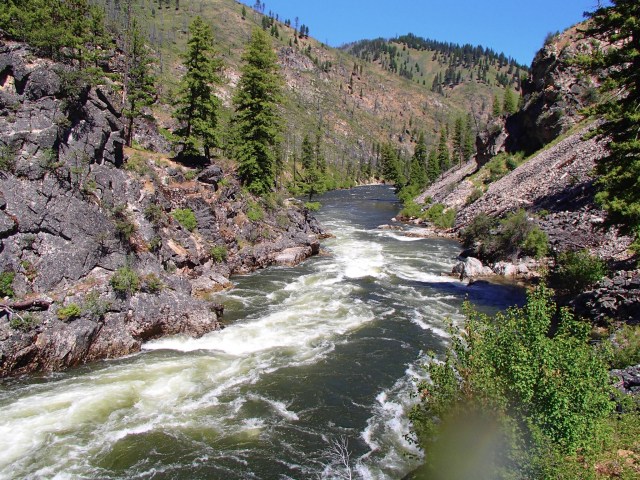 The canyon narrows at this spot and the waves can be dicey in high water. Each time we stopped on the riverbank, there were large groups of butterflies gathered on the sandy beaches. We later heard that they are very attracted to the scat of geese that is found on the sandy shores and also according to scientists “it’s not uncommon in certain areas to see a whole mess of butterflies sitting on the ground, sucking up mud.
 This practice is known as “mud-puddling” or simply “puddling,” and scientists believe certain butterfly species do it to round out their salt, nitrogen, protein, and amino acid intake”. (Just couldn’t resist adding a little science in!) After scouting, a decision was made to go ahead and run Pistol Creek carefully avoiding the giant hole. We continued on past Indian Creek Ranger Station and launch site and watched a private group sliding their raft down the wooden planks into the river.
 Later, we enjoyed a great lunch of chicken tacos and then took a short hike to the foundation of a home of former quartz miners. We continued hiking up the hill to view their old quartz mine and on around the surrounding area near the river to see leftover deposits of quartz and also the former dugouts of the Sheepeater Indians who made their home in the canyon years ago. Everywhere we walked, we were surrounded by giant Ponderosa Pines and firs. Short history fact- the Native Americans used pine resin for medicinal purposes such as mixing it with water to make a tea for curing stomach ulcers and arthritis, applying to cuts to stem blood flow, using it like glue to waterproof and repair items, and also as a fire starter.
 After getting settled, Bob and I noticed a corn snake slithering right through the middle of our tent area. We didn’t share our discovery until a few days later as some campers may not have slept well that night knowing the close proximity of any kind of snake! After enjoying delicious dinner of spinach lasagna and salad, Bob, David, Jimmy and Dave could not resist the challenge of climbing up the high hill above camp. About 20 minutes after they began as we watched them separate and choose various routes on their steep climb up, we noticed a small shirtless figure to their left. Grandpa Greg had taken off up the hill and appeared to be quickly gaining on them. He beat them all to the top where they enjoyed some amazing views and displayed a quintuple “full moon”, which we at camp fortunately were too far away to appreciate.


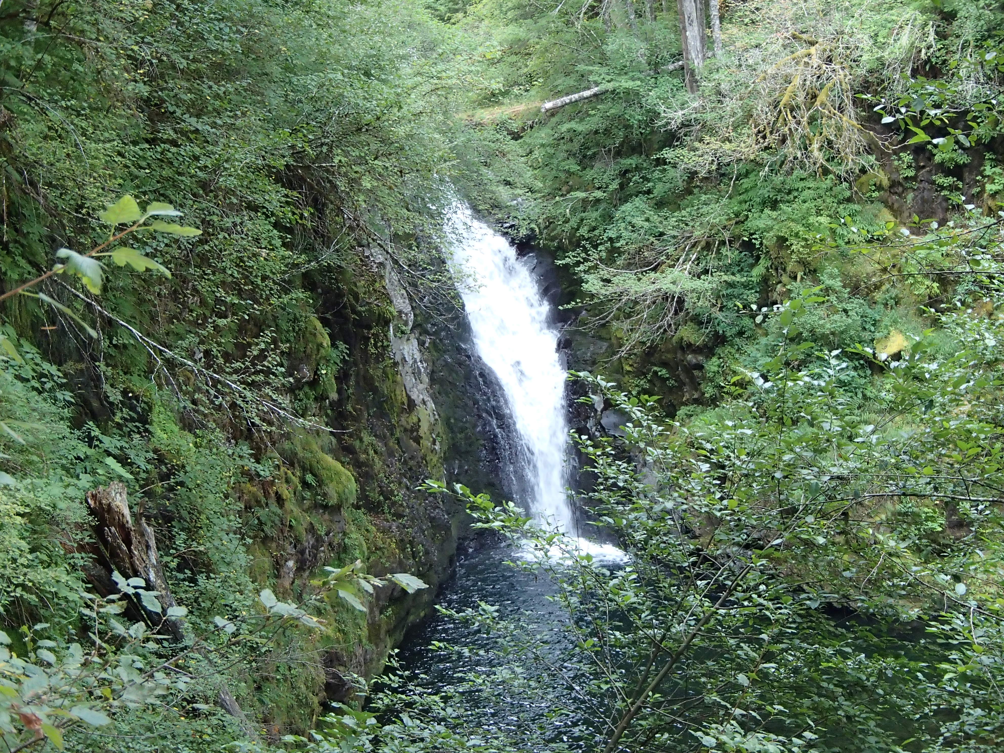
 We loaded up on the boats and stopped fairly quickly for another view of the Native American pictographs low on a canyon wall. It was really interesting to see the people, animals and hunting scenes depicted and left on the walls from such a long time ago. We continued on down the Salmon through Waterfall Creek Rapid to Big Creek Bridge. We walked across the bridge from the west side of the river and saw one of the few trails that lead out of the canyon. We hiked up to a gorgeous waterfall that we had seen from the river below just before we passed under the bridge.


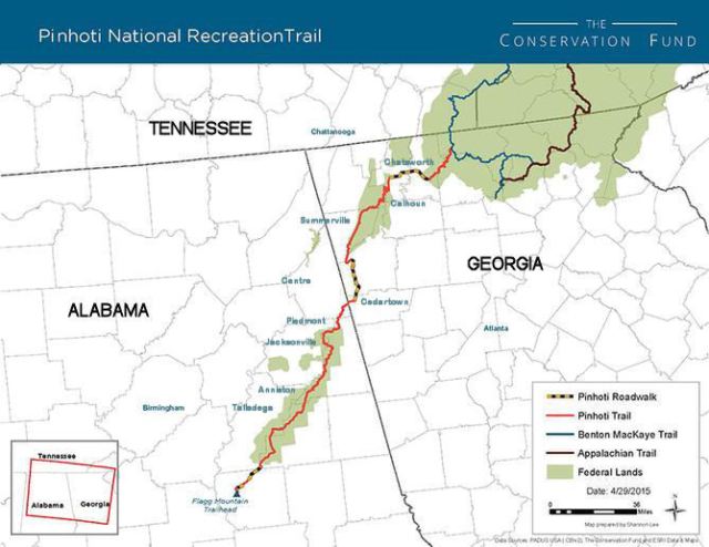
 I just finished my Pinhoti Trail thru hike a couple of weeks ago and for the first time I wasn’t a complete purist on the trail. I skipped over a very small section at Strawberry Mountain around the Lafayette area where I was enjoying a break from the trail (or the Georgia logging roads) visiting with some great friends and family. I’m still all good with that decision. If I knew then what I know now about the Georgia Pinhoti sections, I would have skipped out on a whole lot more than I did. More on that topic in a bit.
 From the Georgia Pinhoti Trail Association website: “The original plan for the Appalachian Trail was laid out in 1925 at the first Appalachian Trail Conference. This plan showed a main trail running from Cohutta Mountain in north Georgia to


 The original plan was that we would have it completed in time for me to start my section hike of the CDT this spring. Well, that hasn’t worked out either. We’re very close to finishing, but still have a number of items to complete, so I’m going to postpone my CDT journey now until at least 2017. Hopefully, we can get moved and everything completed this summer. If that all works out, I’m now planning on doing the